
One studio to scan the land, design the layout, test the deal and track approvals. Then show buyers the project in 3D and AR. Built by an advisory group that sits with buyers every day.
Draw less. Know more. Sell it clearly.
The real Studio, at work.
A screen recording of the live Development Studio: a parcel loads, towers rise, the price book and deal room fill in, then the same land becomes a plotted layout. Tap a chapter to jump to it.
Recorded on the Studio's sample parcel, an invented shape for trying the tools, not real land. Concepts are studies, not approvals.
Understand the land. Design for the ground. Decide with your own numbers. Deliver what you promised.
- 1Understand
- 2Design
- 3Decide
- 4Deliver
From a parcel to a plan you can defend.
Four stages, one workspace. Tap a stage to see what it does, what it reads and what it leaves for you to decide.
Know the land and the ground before you draw on it.
Open Land intel to check the title and records, then the Site scan. Drop in a LiDAR survey file and it reads slopes, water paths, trees and earthworks. No survey yet? Start from public elevation and satellite heat, clearly marked as public data.
- Reads LAS, LAZ and XYZ files on your own computer, in the background. Nothing is uploaded.
- Without a file, shows public elevation (about 30 m) and Landsat heat, always labelled as not LiDAR.
- Bulking, storm and runoff values are editable. Earthwork rates start at zero so you enter your own.
- Drop a pin of any size anywhere around Bengaluru and the Parcel radar reads the village, authority, land rate, roads, drains and ground as you drag.
- Land intel adds 80 checks on survey number, RTC (Pahani), mutation, title chain, encumbrance, conversion and location, with the map screen done for you.
- LandYield turns your acres into saleable plots and compares selling, joint development and building the layout yourself.
Your whole project on your whole land, before it costs a rupee.
Parcel Twin is a drag-and-drop digital twin of a full land parcel. Place residential towers, offices, retail, warehouses, factory sheds, amenities, roads and utilities. Resize and rotate anything, then read the layout, the MEP, the programme and the cost as you build.
- The layout looks right on paper, then FAR, setbacks and tower gaps fail at sanction.The layout check reads FAR, coverage, height, setbacks and gaps live, and outlines the building that breaks a rule.
- STP, water tanks and transformers get sized late, after the towers are fixed.The MEP planner sizes water, sewage, power, fire reserve and lifts from what you placed, and lets you test STP type, water reuse, solar and cooling.
- Are we paying the right price for the land, or the right JD share?LandBid works back from your revenue and cost to the most the land can bear, with sensitivity grids and a JD against purchase comparison.
- Contractor quotes use different formats, quantities and exclusions.VendorCompare puts every vendor on the same items, prices what each left out, and flags rates far from the middle.
- The budget overrun shows up when it is too late to act.CostGuard compares budget, spend and amounts owed with how much is built, and forecasts the final cost building by building.
- Approvals, documents and deadlines live in different inboxes.ApprovalDesk lists the approvals your project is likely to need, who decides, the documents to attach, what is missing and what is overdue.
- Nobody can say how far behind the site really is.ProjectPulse takes weekly site reports with photos and compares them with the planned build, with the reasons for delay counted.
- Sales and cash flow are tracked in different places.SalesFlow turns bookings into monthly collections tied to build progress, against spend, and shows when cash goes negative.
- Mixed use fights over parking, roads and fire access.Parking is counted against the homes, offices and sheds you placed, and roads and gates are part of the plan.
- Phasing is argued in meetings, with no picture of the cash it needs.Give each building a phase, press play, and watch the parcel get built beside a month-by-month spend chart.
- The land itself has papers, lake or drain risks nobody has opened.Run the 80 land checks and GeoVerify on the same parcel before you commit capital.
- Sales cannot show buyers a project that is not built yet.Turn the same project into a 3D and AR microsite that buyers can walk through on a phone.
Layout checks and MEP figures use planning-level norms that you can edit. They help you test a layout early. They do not replace your sanctioned plan, a structural design or a licensed MEP consultant.
Turn your under-construction project into a place buyers can walk through.
Most buyers decide before the tower is built. Give them the whole project in 3D: the facade, every home type, a cut-away of the interior, a game-style walk through a home, and the project on Bengaluru's 3D property map. Recorded live from the product, with Prestige's Fernvale and Falcon City as the examples.
- Facade and siteTowers, podium, amenities and roads, drawn to the project's mapped outline and heights, or from your brochure plans.
- Every home typeSaleable and carpet area, balcony, and which tower and floors each type sits on, straight from your brochure.
- Interiors and walk-throughA cut-away of each unit, and a game-style walk with W A S D. Where no plans are loaded, a clearly labelled sample home shows how it will work for yours.
- On the city mapYour project sits in DesiPropVERSE beside its price, AlphaScore and surroundings, and under-construction projects are drawn part-built.
The Fernvale model is built from Prestige's published brochure: unit areas as printed, room positions traced by hand, furniture ours. Falcon City uses mapped outlines and heights, and its walk-through home is a labelled sample. Neither is shown as the approved design.
Let buyers see the sample flat in their own living room.
A buyer opens your project's link on a phone, points the rear camera at a table or the floor, and your project stands there in 3D. They walk around the towers, open a home as a cut-away, and look at the rooms, from their sofa, with their family, at their own pace.
- 1See the project. The whole site, towers, podium and amenities, at table-top scale.
- 2See the units. Pick a home type and read its area, tower and floors.
- 3See the interiors. Open a cut-away of the sample flat, room by room, with sizes as printed in your brochure.
- 4Share it. One link on WhatsApp, or a QR code on your site hoarding or brochure. No app to install.
Works in the phone's browser on the rear camera. Tracking quality depends on the phone, and we have not yet tested on a wide range of real phones. Models are our renderings from your plans, not the final building.
A live run of the AR view, recorded in a phone-sized browser with a test camera picture standing in for the room. The model is real, the room is not.
80 checks that say the land is clean.
Survey number, RTC (Pahani), mutation, chain of title, encumbrance, conversion, khata and location, tracked in the Development Studio beside your layout. The map screen is done for you. The papers are read by you, your advocate or the DesiAcres land desk.
- ASurvey and boundaries10 checks
- BRecords of rights10 checks
- CTitle and ownership12 checks
- DEncumbrance and litigation10 checks
- ELand use and conversion10 checks
- FKhata, tax and approvals8 checks
- GLocation, environment and risk12 checks
- HDeal and execution readiness8 checks
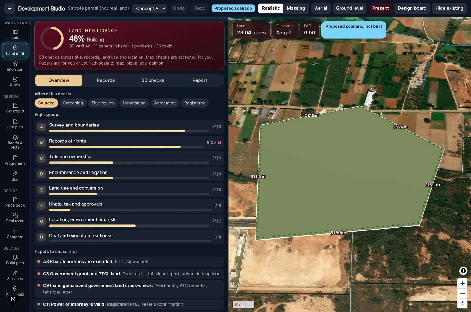
Screenshot of the Studio's Land intel on its sample parcel, with some checks marked to show how the desk reads. Not real land.
One studio for every state.
Pick your state and city and the Studio opens there, with that state's land records, RERA authority and area units ready. The layout, floor plan, construction, deal and approval tools work anywhere in India, and 24 states and union territories have a records guide.
Tap a state. Each tile is one state or union territory.
Maharashtra
- Record of rights7/12 extract (Satbara) and 8A
- MutationFerfar (mutation entry)
- SurveySurvey or Gat number
- Area unitsHectare and are, gunthas in common use
Start from
Every state and city, in one list
Karnataka: Bengaluru, Devanahalli, Mysuru, Mangaluru, Hubballi, Belagavi
Maharashtra: Mumbai, Pune, Thane, Navi Mumbai, Nagpur, Nashik, Chhatrapati Sambhajinagar
Telangana: Hyderabad, Warangal, Karimnagar, Nizamabad
Andhra Pradesh: Visakhapatnam, Vijayawada, Guntur, Tirupati
Tamil Nadu: Chennai, Coimbatore, Madurai, Tiruchirappalli, Hosur, Salem
Kerala: Kochi, Thiruvananthapuram, Kozhikode, Thrissur
Gujarat: Ahmedabad, Gandhinagar, Surat, Vadodara, Rajkot
Delhi: New Delhi, Dwarka, Rohini
Uttar Pradesh: Lucknow, Noida, Ghaziabad, Kanpur, Varanasi, Agra, Prayagraj
Haryana: Gurugram, Faridabad, Panipat, Karnal, Sonipat
Punjab: Ludhiana, Amritsar, Mohali, Jalandhar
Rajasthan: Jaipur, Jodhpur, Udaipur, Kota
Madhya Pradesh: Indore, Bhopal, Gwalior, Jabalpur
Chhattisgarh: Raipur, Bilaspur, Bhilai
West Bengal: Kolkata, Howrah, Siliguri, Durgapur
Odisha: Bhubaneswar, Cuttack, Rourkela
Bihar: Patna, Gaya, Muzaffarpur
Jharkhand: Ranchi, Jamshedpur, Dhanbad
Assam: Guwahati, Dibrugarh, Silchar
Goa: Panaji, Margao, Mapusa
Uttarakhand: Dehradun, Haridwar, Haldwani
Himachal Pradesh: Shimla, Solan, Dharamshala
Jammu and Kashmir: Srinagar, Jammu
Chandigarh: Chandigarh
Land records are guided from each state's official portal. We do not read owner or survey records for any state, and portals change, so confirm on the page. Detailed village, ward and drain data is for Bengaluru today.
Every tool a developer desk needs, in one place.
Use them on their own or together. Each one opens in your browser, with no installation.
Tools you can show your lawyer.
Developers are the people who live with a wrong number longest. So the studio labels what it knows and leaves the rest to you.
- ✓Public data stays labelled as public data. Elevation at about 30 m and Landsat heat are never shown as LiDAR.
- ✓Sample layouts say so. Where we have no approved plan, the 3D layout carries the words Sample layout, not the approved plan.
- ✓Your numbers, not ours. Margins, rates and ratios start as editable starter values. Nothing is presented as a market quote.
- ✓No invented availability. Plot or unit availability is shown only if you give it to us, with its date.
From hello to live in three steps.
- Tell us about the land or projectUse the form below, WhatsApp or a call. A few lines about where it is and what you want to decide are enough.
- We scope it in writingA DesiAcres advisor calls you in working hours, agrees what we will do and the fee, and writes it down before any work starts.
- We set it up and stay till it is liveStudio access, 3D and AR, price book and listings, or land advice, with one person you can reach until closure.
Straight answers.
Does the Development Studio have an AI assistant?
Yes. The glowing AlphaX AI button inside the Studio opens AlphaX with your parcel in view: the map screen, your 80 land checks, the papers you have read and your layout. Ask what to do next, what a check means, which papers to collect, or for a brief for a landowner. Your deal numbers are shared only if you turn that on.
What is Land intelligence in the Development Studio?
A desk with 80 checks on the title, records, land use and location of a parcel: survey and hissa numbers, RTC (Pahani), mutation, chain of title, encumbrance and litigation, conversion, khata, drains and lake buffers, access and deal readiness. Map checks are screened for you, your survey extents are compared with the area you measured, and the papers are tracked for you, your advocate or the DesiAcres land desk to read.
Does DesiAcres verify title and records for developers and landowners?
Our land desk can run the title and records checks on a written mandate, and the Studio tracks all 80 checks, the papers collected and the problems found. A legal opinion on title comes from a licensed advocate.
Is my survey or land data uploaded to DesiAcres?
No. LiDAR files (LAS, LAZ, XYZ) are read on your own computer in a background worker. The scan results stay in your browser unless you choose to share them with us.
Is the Site scan real LiDAR?
It reads real LiDAR when you bring a survey file. Without one, it shows public elevation at about 30 m and Landsat satellite heat, and labels both as public data, never as LiDAR. We do not fly scans ourselves.
Can the Development Studio replace my architect or approvals?
No. It is a feasibility and presentation tool. Rules, setbacks and floor area ratio are starting values you set. Licensed architects, structural engineers and the planning authority decide what can be built.
Are the prices and costs in the studio real?
They are starter values you can edit. Floor prices are estimates, earthwork rates start at zero, and nothing is presented as a quote or a market price until you enter your own.
How do I get my project on the 3D map and in AR?
Tell us the project and share the site location and unit plans through the form. Projects are pinned on the map only once the site location is verified, and unit plans are modelled from what you give us.
What do you charge developers?
Scope and fee are agreed in writing before any work starts. Commercial partners see the proposed fee table before they apply. Nothing is payable without a written agreement.
Do you also help landowners who want a builder?
Yes. DesiAcres advises landowners on joint development terms and has coordinated land aggregation for multi-owner parcels. The developer desk and the land desk work from the same data.
Bring us a parcel. Leave with a plan.
Tell us what you are building or holding. A named DesiAcres advisor will call you, agree the scope in writing and take it from there.
DesiAcres Advisory Group provides advisory and technology services. The Development Studio is a feasibility and presentation tool, not an approved plan, a structural design or a valuation. Approvals rest with the planning authority and licensed professionals. RERA: ACK/KA/RERA/1251/309/AG/250425/006139.